

















The severe riverine floods threatening 15 Nigerian states and disrupting the broader West African region are not isolated incidents. They mark the culmination of a regional environmental crisis that has evolved over more than half a century.
While extreme weather events have grown in frequency and severity, researchers and policymakers emphasize that human activity, historical environmental shifts, and structural governance deficits have consistently compounded the region’s climate vulnerability.
Historical Timeline: From Sahelian Droughts to Systemic Floods
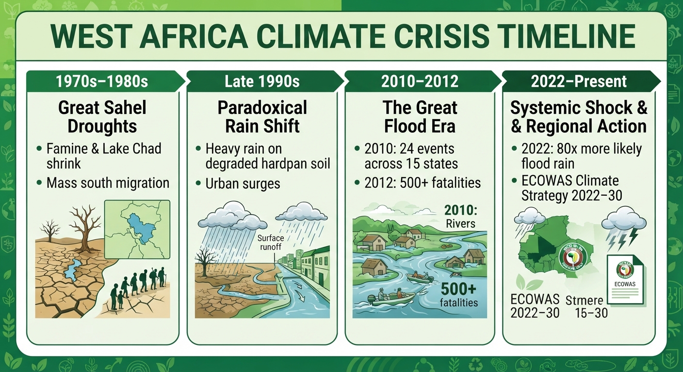
Understanding West Africa’s climate vulnerability requires examining four distinct historical phases over the past 50 years:
1970s–1980s (The Great Sahel Droughts): West Africa experienced its first major modern environmental shock through prolonged droughts. Rainfall dropped sharply across the Sahel, triggering severe famines, the drastic shrinking of Lake Chad, and extensive rural-to-urban migration.
Late 1990s (The Rainfall Paradox): As seasonal monsoons partially returned, they hit soil that had suffered deep degradation and hardpan crusting. Rather than soaking into underground aquifers, heavy rains generated extensive surface runoff, shifting the primary climate threat from water scarcity to severe riverine flooding.
2010–2012 (The Era of the Great Floods): Flood occurrence surged across West Africa, rising from an average of less than three significant events annually before 1998 to nearly 12 per year. The 2012 disaster killed over 500 people in Nigeria alone, highlighting severe gaps in dam management and early warning networks.
2022–Present (Compound Climate Shocks): Rapid attribution studies by World Weather Attribution revealed that human-caused climate change made West Africa’s devastating 2022 rainy season 80 times more likely and 20 percent more intense. Today, the region faces compound shocks where localized droughts and sudden deluges occur within the same agricultural season.
Primary Factors Driving the Regional Rise
Environmental scientists, hydrological authorities, and regional bodies like ECOWAS point to five interconnected factors that continue to accelerate the crisis:
Although West African nations generate less than 2 percent of global greenhouse gas emissions, the region’s warming rate remains disproportionately high. Higher atmospheric temperatures strengthen the West African Monsoon’s intensity, creating short, hyper-intense rainfall events that overwhelm natural river systems.
West Africa has lost vast swathes of its forest cover since 1900. Tree canopies and root networks naturally absorb rainfall, slow down surface runoff, and anchor topsoil. Without forest cover, heavy seasonal downpours sweep across open land into primary basins like the Niger and Benue, triggering sudden flash floods and severe soil erosion.
Driven by population growth and rural economic distress, millions of residents have settled along riverbanks and low-lying floodplains. In cities like Lagos, Accra, and Niamey, concrete paving prevents natural water infiltration while inadequate drainage infrastructure traps runoff inside residential zones.
Regional water infrastructure has struggled to adapt to changing rainfall patterns. Key dams, such as Cameroon’s Lagdo Dam along the Benue River, must periodically release excess water during intense rainy periods to prevent structural collapse. Without secondary control dams downstream in neighbouring countries, these controlled releases flood downstream agricultural communities.
Read also: 14,000 Communities Were Warned. Is Nigeria Listening?
Though ECOWAS adopted its Regional Climate Strategy (2022–2030) to coordinate adaptation efforts, national enforcement of zoning laws, clearing of municipal waterways, and early warning evacuations remain inconsistent. This implementation gap leaves vulnerable populations exposed to predictable seasonal disasters.